Housing and place in central Connecticut
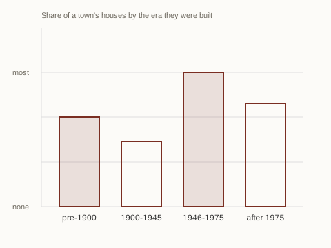
What a town is built of, by era 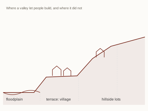
Why villages sit on the terrace 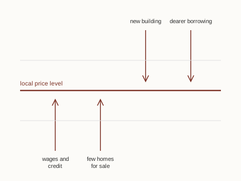
The push and pull on a price level 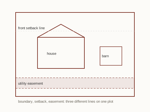
Three different lines on one plot
This site explains how housing works in one part of Connecticut: the river towns, the old quarry and mill villages beside them, and the manufacturing towns spread west and north. It is written for the person who wants to understand the machinery rather than be sold anything. Nothing here is for sale, nothing is listed, and no property, loan or legal situation is assessed. What follows is explanation: how a thin local market sets a price, what a survey is actually looking for, what a mortgage really costs across its life, and why a nineteenth-century brownstone village and a 1958 subdivision two miles apart behave like different markets.
Recent dispatches
More
A market is a conversation between very few people
The phrase "the housing market" suggests something like a stock exchange: continuous, liquid, thick with participants. A town's housing market is nothing of the sort. In a community of eight thousand people there may be a few hundred sales in a year, spread across wildly unlike houses, and no two of them identical enough to be true substitutes. Every number anyone quotes about such a place is drawn from a small handful of events.
That thinness has consequences that people usually attribute to sentiment. A single unusual sale on a short street becomes the reference point that the next four sellers and their buyers argue over, because it is the only recent evidence anyone has. A quiet quarter with few transactions produces figures that swing violently, not because the town changed but because the sample changed. When a market is thin, apparent volatility is mostly arithmetic.
It also means information travels slowly and unevenly. A price agreed in March is recorded in May and appears in a summary in July, by which time borrowing costs may have moved twice. Anyone reading a headline figure is reading the past, filtered through a small sample, described in a single number that flattens a floodplain cottage and a hillside colonial into the same statistic.
What is explained here
How the market works
Why a town's housing market is thin rather than liquid, how a small number of sales sets a reference price, what actually pushes that level up or down, and how to read a summary figure without being misled by it.
The mechanics of a sale
What each stage of a purchase or sale is for, why a contract has periods attached to it, what a boundary survey answers that a home inspection does not, and what the title search is protecting against.
Money and tenure
Amortisation without the jargon, what a fixed rate is really fixing, what points and escrow do to the number you pay, and why renting and owning are two different cost structures rather than two moral positions.
How this site is written
General, not particular
Everything here describes how things usually work. It is not an assessment of any property, loan, contract or situation, and it is not advice.
A defined geography
The place writing covers the river towns, the quarry and mill villages and the industrial corridor west and north of them, and says so plainly rather than claiming the whole state.
Written to be checked
Mechanisms are explained so a reader can test them against what they see. Where a figure would depend on the year, the lender or the town, the article says so instead of inventing a number.
Where this writing is set
The site's place writing is grouped into three parts of one small region. The list below is the whole of it; the schematic beside it shows how the groups sit relative to the river, and is a diagram rather than a map to scale.
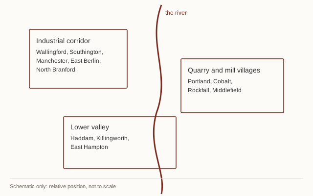
Lower valley
Haddam, Killingworth, East Hampton
Landing settlements, farm parcels and a long stretch of low-density building.
Quarry and mill villages
Portland, Cobalt, Rockfall, Middlefield
Brownstone and mill work, and the compact worker housing that followed it.
Industrial corridor
Wallingford, Southington, Manchester, East Berlin, North Branford
Grid streets around old works, then post-war tract expansion on the farmland behind them.
Recent explainers
Surveys, inspections and what findings mean
A survey answers where the lines are; an inspection answers what condition things are in. They are routinely confused, and the confusion is expensive.
Title, searches and the paperwork behind a sale
The search exists because ownership is a history, not a fact. What a chain of title, an easement and a lien each actually record.
Mortgages in plain terms
Amortisation, term length, points and escrow, and why the headline rate is only one of the numbers that decides what a loan costs.
Renting and owning
Two different cost structures with different risks attached. The usual comparison hides most of the assumptions that decide the answer.